Posts

Showing posts with the label britain

3. The Cambrian Way OEX bush pro Bivvi wet sleeping bag no mat in strong rain and wind The Blorenge.

Image
Day Three on the The Cambrian Way mountain trail 479 km (298 miles) with a total ascent of 22,460 m (73,700 ft). I think it could be Britain's hardest long distance trail. Its hard to say but looking at the map i think i started todays episode around the Mynydd Garnclochdy area i want give exact camping locations away. I was so wet from the rain all night i set about getting ready to walk around 4am just to keep warm. I was no risk at cold from the time of Year and in good health. So walked back up towards Mynydd Garnclochdy i think. The rain came back on top the hill. The rain was very bad so much so i could only see about couple of meters ahead what with the mist as well as the dark even with two powerful lights. By this time my cannon camera was destroyed by the weather i should know by now and my phone was useless take note people think phone navigation fine lucky i know this i used my garmin fenix3 gps watch with the track loaded onto so i knew i was heading in the general dir...

Wild camping Pathless, boggy, rough pathless cliff-top steep ground in ...

Image
Filmed on the 29/05/2017 since then my video skills and equipment has improved alot :) I started of above the Storr but the official start this hike is at the Storr carpark. From the cardpark there is a short walk along the  A855. Then its a walk across a bridge at hydro-electric power pipes. Not long after that you go across soggy moorland until you reach  edge of the escarpment with views of the sea. Walk along there until you descend Ben Tianavaig, Braes. Ben Tianavaig, Braes is steep. I wild camped on the coast path just before got into Portree Wild camping in the jack wolfskin gossamer tunnel tent Equipment used in this video Skye Trail Map @ https://amzn.to/2SPnol3 The Skye Trail guide @ https://amzn.to/2Y6Nrtu Storr and Trotternish map @ https://amzn.to/2Y6UIK0 Jack Wolfskin Gossamer tent @ https://amzn.to/2CGjwMl Salomon Men's Trail Running Shoes, XA Pro 3D GTX @ https://amzn.to/2Yx9Igv Deuter Quantum @ https://amzn.to/2YAZwU8 The Skye Trail day 3 stage...

Wild camping Britain largest landslide with jack wolfskin gossamer tent ...

Image
Filmed on the 28/05/2017 since then my video skills and equipment has improved alot :) Trotternish is one of the most spectacular landscapes in Britain. The great ridge which forms its backbone is the longest on Skye, and its unique eastern escarpment has been broken by Europe's largest landslides into a remarkable landscape. A very long and challenging walk with much ascent and descent. There are some very steep parts up and down i managed it with a big backpack. You need a good level of fitness and know how to use a map or gps. Is possible to camp up on the ridge but its very exposed make sure you there no storms predicted. This part my Skye trail hike. I did this stage in one go. This stage is hard going if doing in one go with a backpack. Wild camping in the jack wolfskin gossamer tunnel tent and using the SPOT Gen3 GPS Satellite Tracker / Messenger Equipment used in this video Skye Trail Map @ https://amzn.to/2SPnol3 The Skye Trail guide @ https://amzn.to/2Y6Nrtu S...

Calanais Standing Stones stone circles just how old really is this? why ...

Image
The Callanish Stones are an arrangement of standing stones placed in a cruciform pattern with a central stone circle. These include at least three other circles, several arcs, alignments and single stones; many visible from the main site. just how old really is this? why was it built? How much has it been altered over time? What is thought is They were erected in the late Neolithic era, and were a focus for ritual activity during the Bronze Age. The existence of other monuments in the area implies that Callanish may have an active focus for prehistoric religious activity for at least 1500 years maybe. Between the central and the eastern monolith of the stone circle is a chambered tomb 6.4 metres long. This may have been built later than the stone circle and is squashed in between the eastern stones and the central monolith. The stones were covered by a thick layer of turf. It is estimated that the place was abandoned around 800 BC. Only in 1857 was the overlying 1.5 metres of peat ...

Snowdonia national park Porthmadog Beddgelert Barmouth

Image
Mountain Walking in Snowdonia: 40 of the Finest Walks in Snowdonia (Cicerone Guides) @ https://amzn.to/2Km500y Lonely Planet Wales (Travel Guide) @ https://amzn.to/2HAUlNL UK views Get cashback on your outdoor store purchases with https://www.topcashback.co.uk/ref/freemoneycashback join free with my link. You can help me out only if you wish to help you can send me a donation to https://www.patreon.com/4seasonbackpacking I was in Snowdonia for over a week so i took in some the sites and cafes around Porthmadog Beddgelert Barmouth in the Snowdonia national park. Porthmadog Beddgelert Snowdonia national park Wales UK Please subscribe. This channel is for you. Please give me your feedback comments. I value every one who takes the time to watch my videos. If you liked the video feel free to press that like button. Think my video may interest others please feel free to share. Just so you do not miss any of my future video uploads click the notification button. Thank you f...

Welcome to the British isles over 6000 islands and epic landscapes

Image
Lonely Planet Great Britain (Travel Guide) @ https://amzn.to/2EBlzCi Lonely Planet Scotland (Travel Guide) @ https://amzn.to/2X6TOJ1 Lonely Planet Wales (Travel Guide) @ https://amzn.to/2HAUlNL Lonely Planet England (Travel Guide) @ https://amzn.to/2HDYfph UK views Get cashback on your outdoor store purchases with https://www.topcashback.co.uk/ref/freemoneycashback join free with my link. You can help me out only if you wish to help you can send me a donation to https://www.patreon.com/4seasonbackpacking British Isles the islands of Great Britain, Ireland, the Isle of Man, the Hebrides and 6000 islands in the North Atlantic.  Total area of about 315,159 km.  population of almost 72 million.  Islands of Alderney, Jersey, Guernsey, and Sark, and their neighbouring smaller islands, are sometimes also taken to be part of the British Isles. The highest mountain Ben Nevis rises to an elevation of only 1,345 metres. Climate is temperate marine, with mild winters an...

Wild camp on the Wales coast path loop hike.

Image
Rombouts Coffee Original One Cup Filters 62 g @ https://amzn.to/2Qn5Qvk Walking The Wales Coast Path  (Cicerone Guide) @ https://amzn.to/2VVsGA9 Force10 Vango F10 Helium UL 1 Tent @ https://amzn.to/2pSBTX9 UK views Get cashback on your outdoor store purchases with https://www.topcashback.co.uk/ref/freemoneycashback join free with my link. You can help me out only if you wish to help you can send me a donation to https://www.patreon.com/4seasonbackpacking This was kind of a loop track some of it was on rights of way and most it on the Wales coast path. Only walking higher up the Welsh coast path to find a camping spot which i did and it was more than perfect. Nice shelter from the spring hot weather and a good flowing river right next my camping spot. Tree nicely hiding my camping spot yet way enough light. One the reasons i not fan normally of forest camping is the lack of light i find it depressing and i dislike fern trees and commercial forests in general. But this w...

From Snowdon summit down The Miners Track Good for first timers

Image
A Pocket Guide to Snowdon: A Guide to the Routes of Ascent @ https://amzn.to/2W4ugir OS Explorer OL17 Snowdon & Conwy Valley (OS Explorer Map) @ https://amzn.to/2JOanp1 UK views Get cashback on your outdoor store purchases with https://www.topcashback.co.uk/ref/freemoneycashback join free with my link. You can help me out only if you wish to help you can send me a donation to https://www.patreon.com/4seasonbackpacking Do you want to walk up a mountain and never have before then The Miners Track  maybe for you. Please note there is steep drops but the path is nice and wide. you will require some degree of fitness and the correct clothes as it can and did snow and next day i had what felt like 30c so you get all seasons in one. If you never have been mountain walking do in the warmest month i would suggest. Now i am also here to give you sound advice from years and 100s of trails and Years outdoor experience i have not only from me but i am sure some of my  viewer...

Stone path across peat bogs.

Image
Stone path across peat bogs. John o' groats & Duncansby head to lands end. Day 51 End to end trail. Milburn. England. Great Britain. UK. www.4seasonbackpacking.co.uk

Wild camping on a remote Devon beach.

Image
Wild camping on a remote Devon beach. John o' groats & Duncansby head to lands end. Day 89 End to end trail. SWCP. Bideford. Devon. England. Great Britain. UK. www.4seasonbackpacking.co.uk

Angel wings shelter.

Image
Angel wings shelter. John o' groats & Duncansby head to lands end. Day 91 End to end trail. SWCP. Clovelly. England. Devon. Great Britain. UK. www.4seasonbackpacking.co.uk

Deer.

Image
Deer. John o' groats & Duncansby head to lands end. Day 8 End to end trail. Loch choire. Highland. Scotland. Great Britain. UK. www.4seasonbackpacking.co.uk

Knockdamph mountain bothy

Image
Knockdamph mountain bothy. A bothy is a free shelter you can sleep in for upto 2 nights if your a backpacker. Most bothies in the UK are in Scotland highlands. I spent the night in this bothy first when i did the cape wrath trail a few years ago and on the day this photo was took on my way to Lands end. Bothies have a sleeping area some times bunk beds and most have a fire place. John o' groats (Duncansby head) to lands end End to end trail. Day 12 Highlands Scotland Great Britain. UK. www.4seasonbackpacking.co.uk

Wild camping day before the big day at Lands end

Image
Wild camping day before the big day at Lands end John o' groats (Duncansby head) to lands end End to end trail. Day 104 Cape cornwall Cornwall England Great Britain. UK. www.4seasonbackpacking.co.uk

Wild camping.

Image
Wild camping. John o' groats & Duncansby head to lands end. Day 14 End to end trail. Ardindrean. Highlands Scotland Great Britain. UK. www.4seasonbackpacking.co.uk

So i made it to Lands end after 105 days :)

Image
So i made it to Lands end after 105 days :) John o' groats (Duncansby head) to lands end End to end trail. Day 105 Cornwall England Great Britain. UK. www.4seasonbackpacking.co.uk

Wild camping

Image
Wild camping. Just before i took this photo a pod of dolphins swam past my tent. John o' groats & Duncansby head to lands end. Day 95 End to end trail. SWCP. Tintagel, Cornwall. England. Great Britain. UK. www.4seasonbackpacking.co.uk

The black bitch pub.

Image
The black bitch pub. One of Scotland's oldest pubs. A "Black bitch" is the term for a native of Linlithgow in Scotland. The inhabitants of Linlithgow, or as it is pronounced locally - Lithgae, are known as the Black Bitches. This is in honour of a black greyhound who swam across the loch to carry food to his master who had been chained to a tree on an island and sentenced to starve to death. The dog is on the town's coat of arms. John o' groats & Duncansby head to lands end. Day 37 End to end trail. Linlithgow. Great Britain. UK. www.4seasonbackpacking.co.uk

Wild camping and camp fire.

Image
Wild camping and camp fire. On this day i hiked just a few km due to the bad weather. Stuck the tent up by a river not best idea when there is a storm. John o' groats & Duncansby head to lands end. Day 31 End to end trail. Clifton. Great Britain. UK. www.4seasonbackpacking.co.uk

Sheep

Image
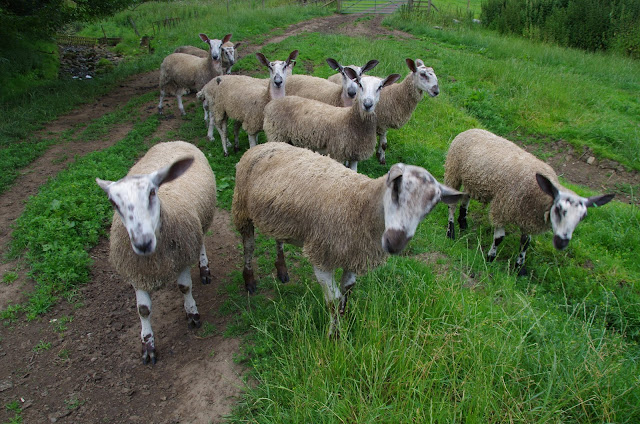
Sheep. John o' groats & Duncansby head to lands end. Day 47 End to end trail. Bellingham. England. Great Britain. www.4seasonbackpacking.co.uk

Wild camping on stanage edge.

Image
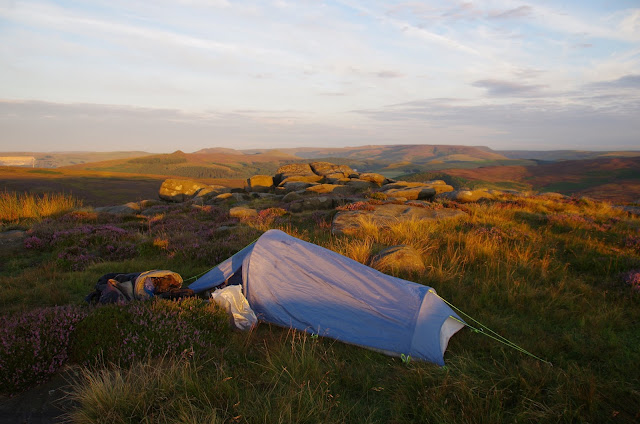
Wild camping on stanage edge. John o' groats & Duncansby head to lands end.  Day 63 End to end trail. Hollow Meadows. Peak District National Park. England. Great Britain. UK. www.4seasonbackpacking.co.uk