Posts

Showing posts with the label backacking

3. The Cambrian Way OEX bush pro Bivvi wet sleeping bag no mat in strong rain and wind The Blorenge.

Image
Day Three on the The Cambrian Way mountain trail 479 km (298 miles) with a total ascent of 22,460 m (73,700 ft). I think it could be Britain's hardest long distance trail. Its hard to say but looking at the map i think i started todays episode around the Mynydd Garnclochdy area i want give exact camping locations away. I was so wet from the rain all night i set about getting ready to walk around 4am just to keep warm. I was no risk at cold from the time of Year and in good health. So walked back up towards Mynydd Garnclochdy i think. The rain came back on top the hill. The rain was very bad so much so i could only see about couple of meters ahead what with the mist as well as the dark even with two powerful lights. By this time my cannon camera was destroyed by the weather i should know by now and my phone was useless take note people think phone navigation fine lucky i know this i used my garmin fenix3 gps watch with the track loaded onto so i knew i was heading in the general dir...

England Scotland Anglo-Scottish border patrol Clennell Street to Cornhill-on-Tweed woods

Image
Last night i wild camped on Clennell Street  had a amazing sunrise on the first day of Autumn. I will walk down Clennell Street today towards cocklawfoot . The walk down was amazing views the whole way. At one point i think i found the worse toilet in Scotland. After the track i came to a road which is where i joined St Cuthbert's Way. Town Yetholm was not long after. Town Yetholm has a small shop which i pigged out and spent almost £20. Not far from Town Yetholm was the border again which where i crossed back into England. I found a abandoned and overgrown cemetery midway between Mindrum and Mindrum Mill. I found some woods by Cornhill-on-Tweed to camp Pennine Way  is a National Trail in England, with a small section in Scotland. The trail runs 268 miles (431 km) Clennell Street is a truly ancient trackway through the Cheviot hills The Cheviot Hills are a range of uplands straddling the Anglo-Scottish border between Northumberland and the Scottish Borders. St Cuthber...

A warm welcome to 4 season backpacking

Image
A warm welcome to everyone. My channel is for you guys. I make these videos for free for your entertainment and maybe we can all learn some thing new from each other. My channel is about Wild camping, Hiking, Backpacking, Urban travel, History, Food drink gear and accommodation reviews. Advice on Videoing Photography.  I love your feedback and your advice to. Let me know what you like to see on this channel. I like to know more about your adventures as well so why not subscribe and i will sub you back. Peace friends and take care. Live it 4 season backpack it You can help me out only if you wish to help you can send me a donation to https://www.patreon.com/4seasonbackpacking

Mosedale cottage bothy to Great langdale campsite

Image
Lake district Day 5 Cumbria England UK Had a lack of sleep at the party house Mosedale cottage bothy where large group of lads turned up at around 1am off there faces and still awake when i left about 9am. Is the Lake district i should known better not really as remote as some other bothies i mean you could even drive up there in a 4wd which i am sure people do. I still think the more remote bothies elsewhere still ok for hikers rather than pissheads and pillheads. Still not wanting sound boring i hope they had a great time. I walked across Mosedale in the wind and rain towards Shap. Dropped my rubbish of there in a street bin. There are no buses in Shap on a Saturday so in end i decided to hitchhike. I have almost 30 years of hitchhiking experience i should do a video on that at some point. Normally small places easy get lift but cities i would not even bother trying now. So i hitchhiked to Penrith where i got the bus to Keswick hoping to stay the Caravan and camping club there. ...

Whiddon Down travelodge & Spinsters' Rock. Day 5

Image

Sourton Cross travelodge to Whiddon Down travelodge. Day 3 & 4.

Image

Granite Way Okehampton to Sourton Cross Travelodge Day 1

Image

Wild camp @ Hill of the dead Stone Row.

Image

Looking back at Horton in Ribblesdale on Pennine Way

Image
Looking back at Horton in Ribblesdale on Pennine Way The Pennine Way National Trail England UK www.4seasonbackpacking.co.uk

Bridge on The Pennine Way

Image
Bridge on The Pennine Way The Pennine Way National Trail England UK www.4seasonbackpacking.co.uk

Ancient cross on The Pennine Way

Image
Ancient cross on The Pennine Way The Pennine Way National Trail England UK www.4seasonbackpacking.co.uk

River thames in Oxford

Image
River thames in Oxford Oxford Green Belt Way. Oxford Oxfordshire England UK www.4seasonbackpacking.co.uk

Red phone box built into a buildings wall in Barton

Image
Red phone box built into a buildings wall in Barton The Donnington Way. England UK www.4seasonbackpacking.co.uk

Backends leading to chapel lane sign in Blockley

Image
Backends leading to chapel lane sign in Blockley The Donnington Way. England UK www.4seasonbackpacking.co.uk

2nd Wild camping spot on The Skye trail

Image
2nd Wild camping spot on The Skye trail The Skye trail Isle of Skye Western Isles The highlands Scotland UK www.4seasonbackpacking.co.uk

A croft on The Hebridean Way

Image
A croft on The Hebridean Way The Hebridean Way The Outer Hebrides Western Isles The highlands Scotland UK www.4seasonbackpacking.co.uk

Wild camping on The Hebridean Way

Image
Wild camping on The Hebridean Way The Hebridean Way The Outer Hebrides Western Isles The highlands Scotland UK www.4seasonbackpacking.co.uk

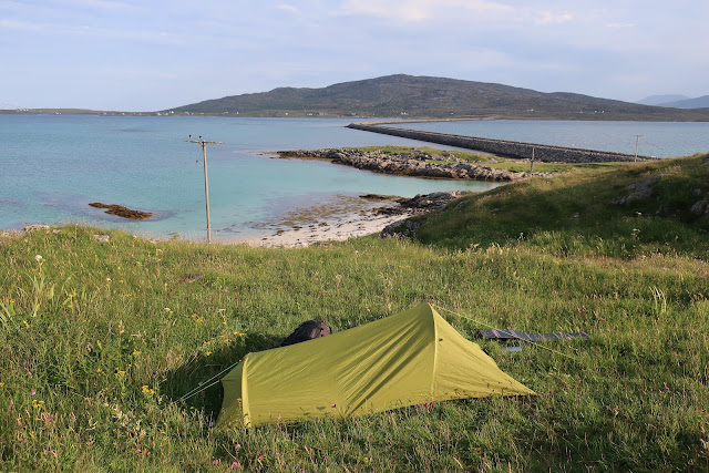
Wild camping @ Eriskay. Looking across the course way to South uist

Image
Wild camping @ Eriskay. Looking across the course way to South uist The Hebridean Way The Outer Hebrides Western Isles The highlands Scotland UK www.4seasonbackpacking.co.uk

Toots at the top of Ironbound range

Image
Toots at the top of Ironbound range South Coast Track Southwest National Park Tasmanian Wilderness Tasmania Australia www.4seasonbackpacking.co.uk

Swinside stone circle also known as Sunkenkirk and Swineshead. Waiting for the end of the World

Image
Swinside stone circle also known as Sunkenkirk and Swineshead. Waiting for the end of the World 21/12/2012. The lake district National park Cumbira. England. UK www.4seasonbackpacking.co.uk

Grey Wethers stone circles.

Image
Grey Wethers stone circles. The Two Moors Way. Coast to Coast. Dartmoor National park Devon. England. Britain. UK www.4seasonbackpacking.co.uk