Posts

Showing posts with the label england coast path

3. The Cambrian Way OEX bush pro Bivvi wet sleeping bag no mat in strong rain and wind The Blorenge.

Image
Day Three on the The Cambrian Way mountain trail 479 km (298 miles) with a total ascent of 22,460 m (73,700 ft). I think it could be Britain's hardest long distance trail. Its hard to say but looking at the map i think i started todays episode around the Mynydd Garnclochdy area i want give exact camping locations away. I was so wet from the rain all night i set about getting ready to walk around 4am just to keep warm. I was no risk at cold from the time of Year and in good health. So walked back up towards Mynydd Garnclochdy i think. The rain came back on top the hill. The rain was very bad so much so i could only see about couple of meters ahead what with the mist as well as the dark even with two powerful lights. By this time my cannon camera was destroyed by the weather i should know by now and my phone was useless take note people think phone navigation fine lucky i know this i used my garmin fenix3 gps watch with the track loaded onto so i knew i was heading in the general dir...

Epic Cornwall Wild camping Mousehole Penzance Sennen cove Lands end Jack wolfskin gossamer tent SWCP

Image
The magnificent South West Peninsula Day Zero i get the national express coach from Birmingham to Penzance for just £18 one way. I arrive late in the dark and strong rain. I then get the M6 First Kernow bus from Penzance to Mousehole. I arrived at Mousehole harbour from there i walked in the dark along the coast path to find a suitable camping spot which i did after not to far out of mousehole. Day one I set of back to Mousehole had a good look around the harbour then got the M6 First Kernow bus back in to Penzance. Got few bits extra food and drink from Iceland supermarket near the bus station then got the open top A1 First Kernow bus to Lands end from Penzance. From lands end i took in the spot i ended my walk that was twice the length of Britain from John o' groats to lands end on the end to end trail. I walked past the First and last house in England. I then headed for Sennen Cove. I camped at wild camped at Maen dower right by waterfalls that going right onto to small ro...

England Scotland Anglo-Scottish border patrol Start of England coast path.

Image
last night i camped at the End of the Anglo-Scottish border The England Coast Path is a proposed long-distance National Trail which will follow the coastline of England. When complete, it will be 2,795 miles (4,500 kilometres) in length. The England Coast Path has been possible because of the introduction of a UK law, the Right of Coastal Access, giving people for the first time the right of access around all England's open coast. This includes – where appropriate – any land, other than the trail itself, which forms part of the coastal margin and which has public rights of access along the way. This is known as ‘spreading room’. However, this does not include any right to enter private houses and gardens or Ministry of Defence land. The new right of Coastal Access also includes 'roll back', namely that if a section of coast erodes, the path will move back accordingly. Berwick-upon-Tweed a small area around Berwick-upon-Tweed, which was taken by England in 1482. Berwi...

Old beach shop perhaps

Image
Old beach shop perhaps Isle of wight coast path Totland bay England. UK www.4seasonbackpacking.co.uk

Danger bathing prohibited

Image
Danger bathing prohibited Isle of wight coast path Norton England. UK www.4seasonbackpacking.co.uk

Swing bridge ruins over Hooe Lake.

Image
Swing bridge ruins over Hooe Lake. Completed in 1887 and closed in 1963. The south west coast path The England Coast Path Plymouth. Devon. England. UK www.4seasonbackpacking.co.uk

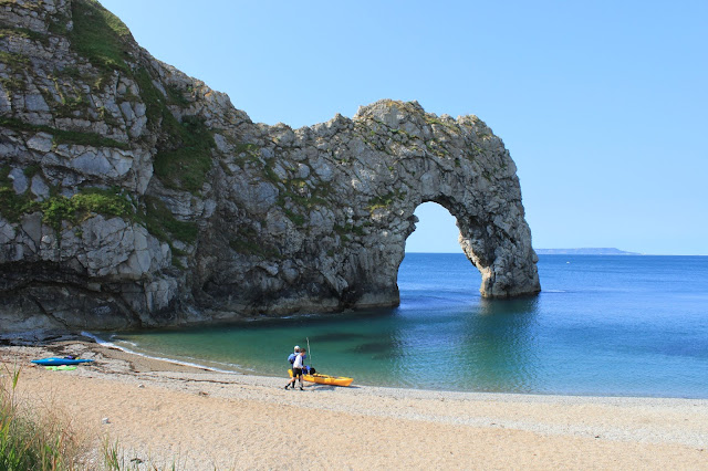
Durdle Door beach

Image
Durdle Door beach. The south west coast. Lulworth. Dorset. England. UK www.4seasonbackpacking.co.uk

Desert boat.

Image
Desert boat. One of the largest expanses of shingle in Europe. Dungeness had such low rainfall as to qualify as the only desert in the UK. However a spokesperson for the Met Office refuted this in 2015. England coast path Dungeness. Kent. England. UK www.4seasonbackpacking.co.uk

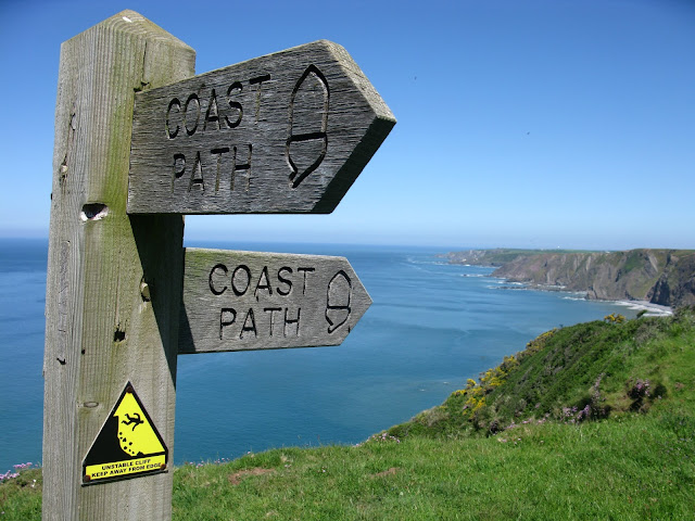
SWCP Sign post

Image
SWCP Sign post The south west coast path Devon England UK www.4seasonbackpacking.co.uk

Horse

Image
Horse. The south west coast path Cornwall. UK www.4seasonbackpacking.co.uk

Red phone box and toll sign at the End of the SWCP

Image
Red phone box and toll sign at the End of the SWCP The south west coast path Next to the famous sandbanks Lilliput. Poole. Dorset. England. UK www.4seasonbackpacking.co.uk

Sheep on top of a cliff.

Image
Sheep on top of a cliff. The south west coast path Cornwall. England. Britain. UK www.4seasonbackpacking.co.uk

Big slow worm (Lizard that looks like a snake)

Image
Big slow worm (Lizard that looks like a snake) The south west coast path Near bude Devon England UK www.4seasonbackpacking.co.uk

Starwars style sunrise in the sea fog.

Image
Starwars style sunrise in the sea fog. The south west coast path. Penzance. Cornwall. Britain. UK. www.4seasonbackpacking.co.uk